Mobile Laser Scanners Market Size, Share & Trends Analysis Report By Type (Handheld Laser Scanners, Mobile 3D Laser Scanners, and Others), By Application (Manufacturing, Construction, Automotive, Aerospace, and Others) and By Region (North America, Europe, Asia Pacific, Latin America, Middle East & Africa) Forecasts, 2026–2034
USD 3950
Mobile Laser Scanners Market Size
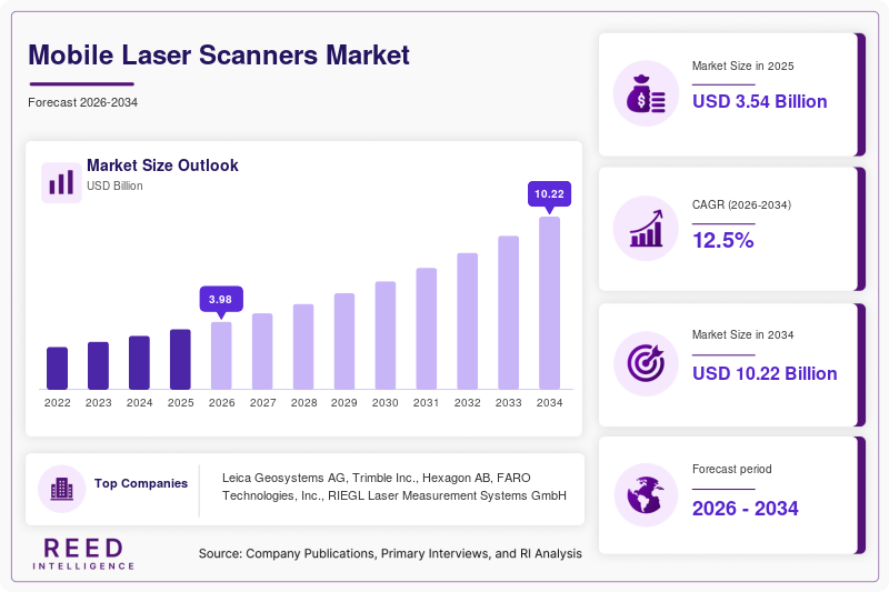
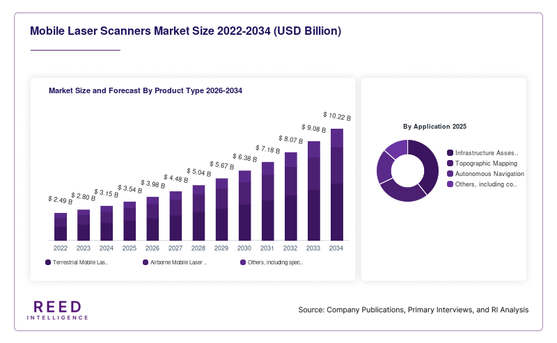
The global mobile laser scanners market was valued at USD 3.54 billion in 2025 and is projected to grow from USD 3.98 billion in 2026 to USD 10.22 billion by 2034, registering a compound annual growth rate (CAGR) of 12.5% during the forecast period (2026–2034).
The Mobile Laser Scanners Market comprises mobile surveying and mapping systems that use laser-based sensing technology, commonly LiDAR, to capture accurate three-dimensional information about roads, buildings, terrain, industrial facilities, and other physical environments. These systems combine laser sensors with positioning technologies, inertial measurement units, and data-processing software to generate detailed point clouds while moving across an area.
Market growth is supported by infrastructure modernization, demand for accurate geospatial information, smart-city initiatives, and the adoption of digital twins. Mobile laser scanning allows surveying teams to collect large volumes of spatial data efficiently, supporting applications such as road-condition assessment, topographic mapping, construction documentation, asset inventories, and autonomous navigation.
Mobile Laser Scanners Market Drivers
Increasing Infrastructure Modernization and Smart-City Development
Governments and infrastructure operators require accurate spatial information to plan, construct, maintain, and upgrade roads, railways, bridges, and urban infrastructure. Mobile laser scanners can capture detailed information across large areas while reducing dependence on slower, point-by-point surveying methods. Their ability to generate three-dimensional datasets supports infrastructure assessment, asset inventories, urban planning, and digital documentation.
Growing Adoption of Digital Twins and Building Information Modeling
Digital twins and Building Information Modeling (BIM) rely on accurate representations of physical assets and built environments. Mobile laser scanners provide point-cloud data that can support existing-condition surveys, renovation planning, construction verification, and ongoing asset management. As organizations increasingly connect physical infrastructure with digital models, demand for reliable reality-capture technologies is expected to support market growth.
Advancements in LiDAR and Mobile Mapping Technology
Improvements in laser sensors, positioning systems, inertial measurement units, and data-processing software are enhancing the capabilities of mobile scanning platforms. Compact systems and SLAM-based technologies can support scanning in environments where satellite positioning is limited. More efficient data collection and improved integration with mapping software are making mobile laser scanning useful across a wider range of surveying and industrial applications.
Mobile Laser Scanners Market Restraints
High Initial Equipment and System Integration Costs
Professional mobile laser scanning systems may require substantial investment in sensors, positioning equipment, computing hardware, software licenses, and data-processing infrastructure. High-end systems can be difficult for smaller surveying firms and organizations with limited capital budgets to acquire. Additional training and integration costs may also affect purchasing decisions, particularly when scanning must be incorporated into established engineering workflows.
Complexity of Data Processing and Interpretation
Mobile laser scanners can generate large point-cloud datasets that require specialized software, skilled personnel, and considerable computing resources. Processing, classifying, registering, and validating these datasets can increase project costs and delivery times. Organizations without experienced geospatial teams may face difficulties converting raw scan data into accurate, usable information for planning and operational decisions.
Accuracy Challenges in Difficult Operating Environments
The quality of mobile laser scanning data depends on sensor performance, positioning accuracy, environmental conditions, and the characteristics of the scanning environment. GNSS signal obstruction, reflective or feature-poor surfaces, weather conditions, and equipment calibration can affect results. Some projects require supplementary measurements, control points, or post-processing to achieve the accuracy standards required for engineering and surveying applications.
Mobile Laser Scanners Market Opportunities
Expansion of Transportation and Infrastructure Mapping
Road authorities, railway operators, and infrastructure contractors require detailed data for asset inventories, condition monitoring, geometric assessment, and maintenance planning. Mobile laser scanning can capture roadway and corridor information efficiently, creating opportunities for manufacturers and service providers. Demand may increase as infrastructure owners adopt digital asset-management systems and update their records more frequently.
Integration of Artificial Intelligence and Automated Feature Extraction
Artificial intelligence and machine-learning technologies can help classify point clouds, identify infrastructure features, detect changes, and reduce manual data-processing requirements. Integration with automated mapping workflows offers opportunities to improve project efficiency and deliver more actionable information. Vendors that combine scanning hardware with software for automated interpretation may be able to differentiate their solutions.
Growth of Digital Twins and Industrial Asset Documentation
Industrial facilities, utilities, construction projects, and large buildings increasingly require accurate digital representations of existing assets. Mobile scanning can support plant documentation, renovation planning, equipment layout verification, and ongoing asset management. Combining mobile scanning with cloud collaboration and digital-twin platforms creates opportunities for equipment manufacturers, software developers, surveying firms, and engineering service providers.
Mobile Laser Scanners Market Segmental Analysis
By Product Type
Terrestrial mobile laser scanners represent the dominant product-type segment, accounting for approximately 54.3% of global Mobile Laser Scanners Market revenue in 2025, according to Dataintelo's published market analysis. These systems capture three-dimensional information from vehicle-mounted or other ground-based mobile platforms. Their use in road surveys, infrastructure inventories, corridor mapping, and urban documentation supports their position in the market.
Airborne mobile laser scanners support mapping from aircraft and other aerial platforms, enabling the collection of spatial data across extensive or difficult-to-access areas. They are relevant for topographic surveys, terrain modeling, vegetation analysis, and large-scale infrastructure or environmental projects. Their suitability depends on project coverage, required resolution, platform costs, and data-processing requirements.
Other mobile scanning configurations support specialized surveying and mapping tasks. Continued advances in compact sensors, positioning technology, and SLAM-based processing may expand the range of environments in which mobile scanning can be deployed. However, the available market estimate does not establish a sufficiently comparable growth rate to identify the fastest-growing product-type segment conclusively.
By Application
Infrastructure assessment is a key application for mobile laser scanners because transportation networks and built assets require accurate records for inspection, maintenance, and modernization. Mobile scanning systems can collect roadway geometry, bridge details, tunnel profiles, and other spatial information. These datasets support asset inventories, engineering assessments, and digital documentation of existing infrastructure.
Topographic mapping is another important application, enabling surveyors to create detailed terrain models and map physical features across large areas. Mobile laser scanning can support land development, corridor planning, and selected environmental mapping activities, with the appropriate system determined by terrain, coverage, and accuracy requirements.
Autonomous navigation provides an additional application as mobile platforms and autonomous vehicles require spatial information to understand their surroundings. LiDAR-derived data can support mapping and environmental perception, although specific requirements vary according to the navigation system and operating environment. The available comparable sources do not conclusively establish which application is the fastest-growing segment or provide a verified dominant application share for the market definition used here.
By Region
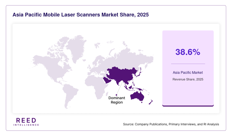
Asia Pacific is the dominant regional market in the cited estimate, accounting for approximately 38.6% of global revenue in 2025. Infrastructure development, urbanization, transportation projects, and the adoption of geospatial technologies contribute to regional demand. China, India, Japan, and other regional markets provide opportunities for mobile scanning in road mapping, construction documentation, urban planning, and infrastructure management.
Regional growth also depends on public-sector investment, access to advanced surveying equipment, the availability of skilled operators, and the maturity of digital mapping infrastructure. The cited source identifies Asia Pacific as the leading region but does not provide a sufficiently comparable regional growth-rate dataset to conclusively identify the fastest-growing region independently.
Mobile Laser Scanners Market Regional Analysis
North America Mobile Laser Scanners Market
North America is an established market for mobile laser scanners, supported by infrastructure management requirements, surveying and engineering services, and demand for detailed geospatial information. The United States and Canada use mobile mapping technologies for transportation corridors, construction projects, utility networks, and industrial asset documentation.
Demand is also supported by the adoption of digital engineering workflows and the need to maintain accurate records of existing infrastructure. Technology providers compete through scanning accuracy, positioning capabilities, software integration, and data-processing efficiency. However, capital costs and the availability of trained personnel can influence adoption among smaller surveying firms.
Europe Mobile Laser Scanners Market
Europe represents an important market for mobile laser scanners due to its established surveying industry, transportation infrastructure, industrial facilities, and adoption of digital construction practices. Countries such as Germany, France, the United Kingdom, and the Netherlands provide opportunities for scanning technologies in infrastructure assessment, construction documentation, industrial mapping, and asset management.
Demand is influenced by infrastructure maintenance, engineering requirements, and the need to document existing structures accurately. The integration of laser scanning with BIM and digital-twin workflows also supports adoption. Equipment providers serving European customers must address project-specific accuracy requirements, software compatibility, and the needs of engineering and surveying professionals.
Asia Pacific Mobile Laser Scanners Market
Asia Pacific is the dominant regional market for Mobile Laser Scanners, accounting for approximately 38.6% of global market revenue in 2025, according to Dataintelo's published market analysis. The region benefits from infrastructure investment, urban expansion, smart-city development, and growing demand for digital mapping. China, India, and Japan are important markets for surveying and mapping technologies used in transportation, construction, and infrastructure management.
Latin America Mobile Laser Scanners Market
Latin America offers opportunities for mobile laser scanners through transportation infrastructure projects, mining operations, urban development, and industrial asset management. Brazil and other major regional markets require geospatial data for infrastructure planning, land surveys, construction, and selected resource-sector applications.
Market development depends on infrastructure investment, equipment affordability, financing, and the availability of skilled surveying personnel. Mobile laser scanning can improve data collection across large or complex project areas, although adoption may be affected by capital constraints and uneven access to advanced geospatial technologies.
Middle East & Africa Mobile Laser Scanners Market
The Middle East & Africa region presents opportunities associated with large-scale construction, transportation infrastructure, urban development, and industrial projects. Mobile laser scanners can support site documentation, engineering surveys, infrastructure inventories, and the creation of digital records for complex assets. Major construction and modernization programs can create demand for precise three-dimensional data.
Adoption varies according to project investment, access to specialized equipment, surveying capabilities, and the maturity of digital engineering workflows. In some markets, equipment costs and the availability of technical expertise may constrain deployment. Partnerships between equipment suppliers, engineering firms, and local service providers can help address these challenges.
Mobile Laser Scanners Market Competitive Landscape
The Mobile Laser Scanners Market includes geospatial technology companies, surveying equipment manufacturers, and providers of integrated mapping hardware and software. Competition is shaped by scanning accuracy, point-cloud density, positioning performance, portability, processing speed, software integration, and technical support. Vendors are increasingly developing connected workflows that link field data collection with cloud processing, collaboration, and digital engineering applications.
Leica Geosystems, part of Hexagon AB, develops surveying, reality-capture, and geospatial measurement technologies. Its portfolio includes mobile mapping systems and laser scanning equipment used in surveying, construction, infrastructure, and industrial applications. The company competes through sensor performance, integrated positioning technologies, software workflows, and established relationships with professional surveying and engineering users. In May 2025, Leica introduced the Pegasus TRK300 mobile mapping system, designed to make advanced mobile mapping more accessible through a lightweight system and AI-enhanced functions.
Key Market Players
- Leica Geosystems AG
- Trimble Inc.
- Hexagon AB
- FARO Technologies, Inc.
- RIEGL Laser Measurement Systems GmbH
- Teledyne Technologies Incorporated
- Topcon Corporation
- SICK AG
- Zoller + Fröhlich GmbH
- GeoSLAM Ltd.
Mobile Laser Scanners Market Recent Developments
- June 2026 – Leica Geosystems launches the RTC series of terrestrial laser scanners Leica Geosystems, part of Hexagon, announced the Leica RTC300, RTC500, and RTC700 terrestrial laser scanners. The new series focuses on scanning speed, accuracy, range, and connected workflows. Its Livelink capability connects field and office teams through real-time scan-data sharing, helping users identify missing data while still on site and begin processing before fieldwork is complete.
- May 2025 – Leica Geosystems introduces the Pegasus TRK300 mobile mapping system Leica Geosystems introduced the Pegasus TRK300 as a mobile mapping system intended to broaden access to advanced geospatial data collection. The system combines mobile data capture with AI-enhanced functions and a lightweight design. Potential applications include infrastructure documentation, urban mapping, and digital-twin development.
Mobile Laser Scanners Market Segments
By Product Type
- Terrestrial Mobile Laser Scanners
- Airborne Mobile Laser Scanners
- Others, including specialized mobile scanning configurations and platforms where included in the market definition
By Application
- Infrastructure Assessment
- Topographic Mapping
- Autonomous Navigation
- Others, including construction documentation, industrial asset mapping, utilities inspection, and environmental monitoring
By Region
- North America
- Europe
- APAC
- Middle East and Africa
- LATAM