Oil and Gas Drones Market Size, Share & Trends Analysis Report By Type (Fixed-Wing Drones, Rotary-Wing Drones, Hybrid Drones), By Application (Pipeline Inspection, Offshore Platform Inspection, Oilfield Mapping and Surveying, Environmental Monitoring, Emergency Response), By End-User (Oil and Gas Upstream, Midstream, Downstream), and By Region (North America, Europe, Asia Pacific, Latin America, Middle East & Africa) Forecasts, 2026–2034
USD 3950
Oil and Gas Drones Market Size
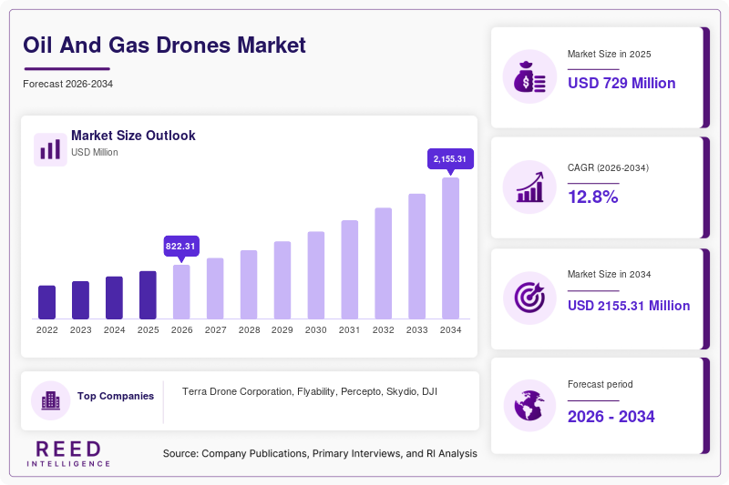
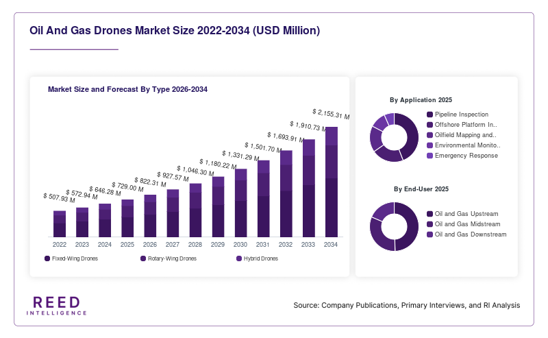
The global oil and gas drones market size was valued at USD 729 million in 2025 and is projected to grow from USD 822.31 million in 2026 to USD 2,155.31 million by 2034, registering a CAGR of 12.8% during the forecast period from 2026 to 2034.
The oil and gas drones market includes unmanned aerial vehicles (UAVs), specialized sensors, inspection software, and related services used across upstream, midstream, and downstream oil and gas operations. These systems support pipeline inspection, offshore platform monitoring, oilfield mapping, environmental monitoring, and emergency-response activities. Drones allow operators to collect aerial imagery and sensor data from large, remote, or difficult-to-access assets while reducing the need for personnel to enter certain hazardous environments.
Oil and Gas Drones Market Drivers
Increasing Demand for Pipeline and Infrastructure Inspection
Oil and gas operators maintain extensive pipeline networks, processing facilities, refineries, storage terminals, and offshore installations. Drones can collect aerial imagery across large areas, document visible infrastructure conditions, and identify locations requiring further inspection. Regular drone surveys can help operators monitor pipeline corridors, assess access conditions, and prioritize maintenance activities. Specialized sensors may provide additional monitoring capabilities when configured for the target inspection task.
Growing Focus on Worker Safety and Operational Efficiency
Oil and gas facilities can expose workers to heights, hazardous substances, offshore conditions, and remote or difficult terrain. Drones can inspect selected structures and conduct preliminary surveys without requiring personnel to access every inspection point directly. This can reduce certain occupational risks and help inspection teams focus resources on areas that require closer examination. Their effectiveness depends on suitable equipment, operator training, and established safety procedures.
Advancements in Sensors, Automation, and Data Analytics
Improvements in high-resolution cameras, thermal imaging, gas-detection payloads, flight-control systems, and automated data processing are expanding drone applications. AI-enabled software can help analyze inspection imagery, identify anomalies, and prioritize assets for follow-up. Autonomous flight systems can support repeatable inspections and scheduled monitoring. However, deployment in hazardous industrial environments requires suitable equipment, reliable communications, operational safeguards, and regulatory compliance.
Oil and Gas Drones Market Restraints
High Equipment and Integration Costs
Industrial drone operations can require specialized aircraft, sensors, software, trained personnel, maintenance, calibration, and data-management infrastructure. Advanced payloads and analytics platforms can increase implementation costs. Integrating drone data with geographic information systems, inspection databases, and asset-management software can also require technical resources. These factors may limit adoption among smaller operators or companies without established drone programs.
Regulatory and Operational Limitations
Drone deployment is affected by aviation regulations, airspace restrictions, site permissions, pilot qualifications, and facility-specific safety requirements. Offshore environments, refineries, and remote pipeline corridors can introduce additional operating challenges. Weather, flight endurance, communications coverage, and hazardous-area restrictions may limit deployment. Drones therefore complement rather than universally replace conventional inspection techniques and certified monitoring systems.
Oil and Gas Drones Market Opportunities
Expansion of Autonomous Inspection and Drone-as-a-Service
Autonomous drone systems and Drone-as-a-Service models offer opportunities for operators seeking recurring inspections without maintaining every element of an internal drone program. These services can provide scheduled data collection, remote monitoring, image analysis, and inspection reporting. Wider adoption will depend on operational reliability, regulatory approvals, data security, and demonstrated cost or safety benefits compared with existing inspection methods.
Methane Monitoring and Environmental Compliance
Environmental monitoring and methane-emissions management provide opportunities for drones equipped with appropriate gas-detection or remote-sensing technologies. These systems can survey selected facilities, identify areas requiring further investigation, and help document conditions over time. Effective deployment depends on sensor capabilities, measurement validation, flight planning, and compliance with accepted monitoring procedures. Not every drone or camera system can detect methane directly.
Oil and Gas Drones Market Segmental Analysis
By Type
Rotary-wing drones are suited to close-range inspections, hovering, and maneuvering around tanks, rigs, processing facilities, and elevated structures. Their vertical takeoff and landing capability makes them useful at industrial sites where runways are unavailable. Their limitations include relatively shorter flight endurance and range than many fixed-wing systems.
Fixed-wing drones are suitable for long-distance pipeline surveillance, broad-area mapping, and surveying extensive oilfield areas. Hybrid drones combine features of fixed-wing platforms with vertical takeoff and landing capabilities, offering potential advantages when both range and flexible deployment are required.
A verified global market-share breakdown by drone type and a comparable CAGR for each type were not established for this report. The dominant and fastest-growing types require market-specific data using a consistent definition and forecast period.
By Application
Pipeline inspection is an important application because operators need to monitor extensive rights-of-way, document visible changes, and identify locations that require further assessment. Drone surveys can support inspection planning, but aerial imagery alone cannot establish the condition of every buried pipeline or confirm every leak.
Offshore platform inspection can reduce the need for direct access to certain elevated structures. Oilfield mapping and surveying support site planning, while environmental monitoring and emergency response provide additional applications. Specialized payloads may expand inspection capabilities, depending on sensor specifications and operating conditions.
Verified market-share percentages and comparable CAGRs for individual applications were not established for this report. The leading application and fastest-growing application should be identified using consistent, market-specific data rather than general UAV-industry statistics.
By End-User
Upstream operators use drones for oilfield mapping, well-pad surveys, selected infrastructure inspections, and environmental monitoring. Midstream operators can apply drones to pipeline corridors, compressor stations, terminals, and storage infrastructure. Downstream operators use them for selected refinery, processing, tank-farm, and industrial-site inspections, subject to facility-specific safety requirements.
Demand across end-user groups depends on asset geography, inspection frequency, workforce-safety priorities, regulatory obligations, and existing asset-integrity systems. A verified market-share breakdown and comparable CAGRs for upstream, midstream, and downstream end users were not established for this report.
By Payload
Visual imaging systems support routine asset surveys and infrastructure documentation. Thermal imaging systems can identify temperature anomalies requiring further examination, while LiDAR and mapping sensors support terrain modeling and asset visualization. Gas-detection payloads can support specialized emissions surveys when designed and validated for the target gas and operating environment.
Payload selection depends on inspection objectives, sensor accuracy, environmental conditions, flight endurance, and data integration requirements. Verified global market shares and CAGRs for individual payload categories were not established for this report.
By Service Model
In-house drone operations provide operators with direct control over flight schedules, data access, and inspection procedures, but require investment in equipment, personnel, maintenance, and compliance. Drone-as-a-Service gives operators access to specialized equipment and trained service providers without requiring a fully developed internal program. Managed inspection services can also include data processing, reporting, and integration into asset-management workflows.
The preferred model depends on inspection frequency, internal expertise, data sensitivity, geographic coverage, and total operating costs. Verified market-share and CAGR figures for the service models were not established for this report.
Oil and Gas Drones Market Regional Analysis
North America Oil and Gas Drones Market
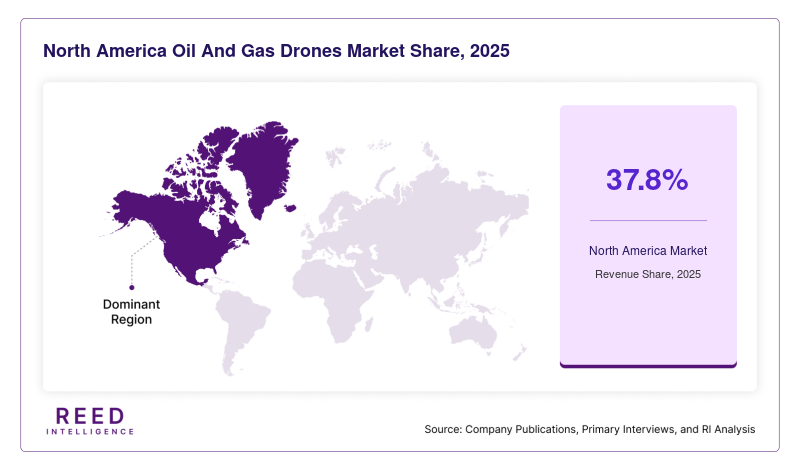
North America is identified as the dominant region in the cited market estimate, accounting for 37.8% of the global oil and gas drones market in 2024. This figure is a historical estimate, not a confirmed 2025 or 2026 market share. It should be interpreted according to the original source's market definition, and further validation is needed before using it as a current-year estimate.
Demand is supported by extensive pipeline networks, established oil and gas production, offshore operations, and industrial inspection requirements. The United States and Canada offer applications in pipeline surveillance, oilfield mapping, remote asset inspection, and environmental monitoring. Aviation regulations, facility-level safety rules, and the availability of qualified service providers influence deployment.
Europe Oil and Gas Drones Market
A verified numerical market share and comparable forecast CAGR for Europe were not established for this report. Demand is associated with offshore energy infrastructure, pipeline networks, refinery operations, and the use of remote inspection and emissions-monitoring technologies. A numerical regional ranking requires comparable data for all regions under the same market definition and reference year.
The United Kingdom and Norway have offshore oil and gas assets that create applications for drone-based inspections. Germany and other European industrial markets have relevant refinery, processing, and pipeline infrastructure. Adoption depends on aviation regulations, offshore safety procedures, weather conditions, and the requirements for reliable inspection records.
Asia Pacific Oil and Gas Drones Market
A verified market-share percentage and forecast CAGR for Asia Pacific were not established for this report. The region has varied oil and gas production, refining, pipeline, and import-terminal requirements, but the available data do not support assigning a precise share or growth rate relative to other regions.
China and India have substantial energy and industrial infrastructure that can create use cases for drone-based surveying and inspection. Australia also has remote energy assets where aerial data collection may support selected operational activities. Adoption depends on local regulations, access to specialized payloads, operator training, infrastructure investment, and the economics of drone-based inspection compared with alternatives.
Latin America Oil and Gas Drones Market
A verified global market-share percentage and regional CAGR for Latin America were not established for this report. Potential demand is associated with oil production areas, pipeline systems, offshore projects, refineries, and remote facilities. Adoption depends on inspection-technology investment, service availability, operating conditions, and the ability to deploy drones safely and legally.
Brazil has offshore oil and gas operations, while Mexico and other regional producers have pipeline, production, and processing assets that may require inspection. Terrain, weather, connectivity, aviation requirements, and the availability of trained operators influence the deployment of drone services. Market-specific data are required to quantify the region's share and growth rate.
Middle East & Africa Oil and Gas Drones Market
A verified market-share percentage and comparable forecast CAGR for the Middle East & Africa were not established for this report. The region's oil and gas production facilities, export terminals, pipeline infrastructure, and processing plants provide potential applications for aerial inspection. A precise regional share cannot be assigned reliably without consistent market-specific data.
Saudi Arabia, the United Arab Emirates, and other Gulf energy producers have large industrial assets where drones may support surveying, inspection, and environmental monitoring. African oil and gas markets also have potential applications across remote production sites and pipeline networks. Extreme heat, dust, site-security requirements, hazardous-area procedures, and local operating permissions can affect deployment.
Oil and Gas Drones Market Competitive Landscape
The oil and gas drones market includes drone manufacturers, autonomous inspection providers, industrial inspection specialists, sensor suppliers, and data-analysis companies. Competition is shaped by flight reliability, sensor compatibility, automation, data quality, operational safety, service coverage, and integration with asset-management systems.
Specialized providers focus on industrial inspections and autonomous operations, while broader drone manufacturers supply aircraft and technologies that can be configured for energy-sector use. Buyers assess payload performance, flight endurance, environmental suitability, software capabilities, cybersecurity, regulatory compliance, and total operating costs. Partnerships among hardware suppliers, inspection contractors, and energy companies also influence the competitive landscape.
Key Market Players
- Terra Drone Corporation
- Flyability
- Percepto
- Skydio
- DJI
- Parrot
- Aerodyne Group
- Cyberhawk
- PrecisionHawk
- Airobotics
- Zeitview (formerly DroneBase)
Recent Market Developments
-
May 2026 -ZenaTech: The company disclosed a proposed acquisition involving a Canadian surveying business serving the oil and gas sector. The transaction is relevant to the expansion of drone-enabled surveying and related services.
-
June 2026 - Percepto: The company's official news page reported activity related to inspection intelligence for energy infrastructure. Specific product or deployment details should be confirmed against the individual announcement before treating the activity as a completed commercial rollout.
Oil And Gas Drones Market Segments
By Type
- Fixed-Wing Drones
- Rotary-Wing Drones
- Hybrid Drones
By Application
- Pipeline Inspection
- Offshore Platform Inspection
- Oilfield Mapping and Surveying
- Environmental Monitoring
- Emergency Response
By End-User
- Oil and Gas Upstream
- Oil and Gas Midstream
- Oil and Gas Downstream
By Payload
- Visual Imaging Systems
- Thermal Imaging Systems
- Gas-Detection Sensors
- LiDAR and Mapping Sensors
- Other Specialized Payloads
By Service Model
- In-House Drone Operations
- Drone-as-a-Service
- Managed Inspection Services
By Region
- North America
- Europe
- APAC
- Middle East and Africa
- LATAM